|
Selected Animations (click images below) |
Suspended Sediment Plumes
Highly reflective coastal suspended sediment plumes are a typical springtime event in southern Lake Michigan (Eadie et al. 1996). This plume is caused mainly by wind-driven sediment resuspension and current convergence in the coastal region. It episodically occurs in early spring due to strong southward wind and is suppressed in early summer as the seasonal thermocline develops. Examples of plume events can be viewed in the 1998 and 1999 surface sediment maps from the Sea-viewing Wide Field-of-View Sensor (SeaWiFS) and wind measurements on NOAA meteorological buoys in the lake. Although the physical processes driving the plume in these two years were the same, spatial distribution of the plume significantly differed in these two years. In March 1998, regions of high sediment-re-suspension were distributed along eastern and western shores, while in March 1999, sediment was restricted to only a limited area around the southwestern shore. |

Click here or image to view the full-size figure. |
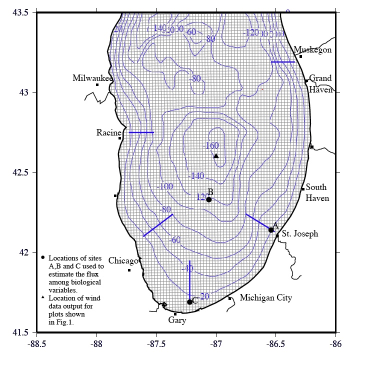
Observed Transects Used for Model-Data Comparisons
As part of the EEGLE observational component, a series of interdisciplinary field measurements were conducted during the March 1998 and 1999 plume events in southern Lake Michigan. Biological measurements were conducted on 3 cross-shore transects near Muskegon, MI, St. Joseph, MI, and Gary, IN in 1998, and 5 cross-shore transects near Muskegon, St. Joseph, Gary, Chicago, IL, and Racine, WI in 1999. The data included water samples and continuous records from the tow-yowed Plankton Survey System (PSS). The modeling effort simulated the observed distribution of nutrients and phytoplankton for both the 1998 and 1999 plume periods, and a process-oriented study addressing questions raised above was conducted by comparing the model results for these two years.
|

Click here or image to view the full-size figure. |
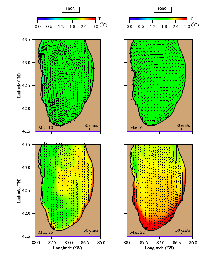
Model-Predicted Currents During 1988 and 1999 Plume Events
In 1998, a strong southward wind prevailed in southern Lake Michigan on 8-11 March, during which the maximum wind speed reached about 10-15 m/s. This southward wind produced strong along-shore southward flows on both the eastern and western shores, as well as two cyclonic circulation gyres in the interior on 10th March. Two convergence zones formed along the eastern coastal area, the first of which was located at the southeastern near-shore region between St. Joesph and Michigan City and the second near Grand Haven between two cyclonic gyres.
In 1999, a strong southwestward wind of about 10-15 m/s swept over southern Lake Michigan on 2-6 March. This southwestward wind caused westward/southwest or northwestward offshore currents on the eastern coast and westward currents in the lake interior. These currents converged toward the western coast, leading to a strong southward transport in the near-shore region of the western coast and thus forming a convergence zone along the southwestern coast near Gary.
|
|
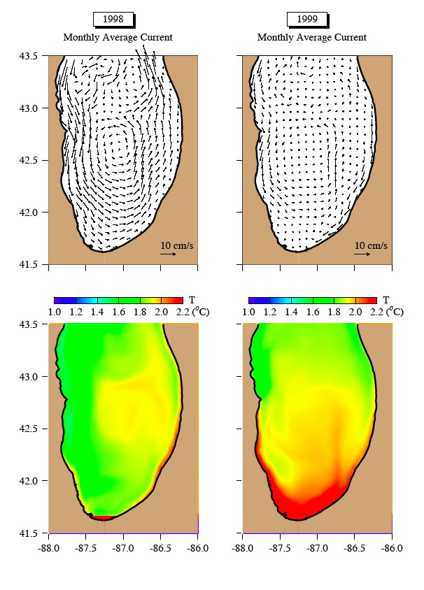
Model-Predicted Monthly Averaged Currents for March 1998 and 1999
In March 1998, the wind-induced monthly averaged currents in southern Lake Michigan were characterized by a relatively strong southward flow of about 10 cm/s along the western coast. This flow rotated counterclockwise in the southern end of the lake to form a cyclonic circulation gyre in the interior. Correspondingly, a cold-water band formed along the western coast as a result of the along-shore southward advection and a relatively warm water patch appeared in an offshore region between Grand Haven and South Haven in association with the cyclonic gyre. In 1999, although there was a southward flow along the western coast, its magnitude was much weaker. This weaker southward coastal flow turned eastward at 42 degree N to form a relatively large scale cyclonic recirculation gyre in the interior. On the eastern coast, the mean flow was also southward. This flow extended southward along the coast to Michigan City and then turned clockwise to join the cyclonic circulation gyre. As a result, a nearly motionless zone formed on the southwestern coast off Gary. The distribution of monthly averaged water temperatures matched well with the circulation: two cold water bands forming on the eastern and western coast in the northern part of southern Lake Michiga; a warmer water area appearing in the interior; and the highest water temperature zone existing in the nearly-motionless southwestern coastal zone.
|
|
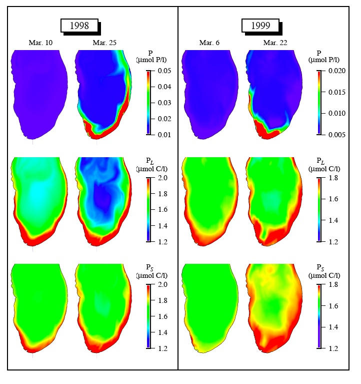
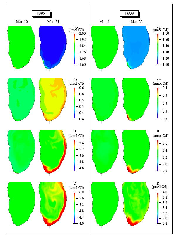
1998 and 1999 Nutrients and Phytoplankton Distributions
In 1998, high phosphorus concentration appeared along the eastern-southwestern coast after 12 March, and intensified significantly after the subsequent southward wind event that occurred on 17-21 March. Offshore transport of phosphorus was clearly evident near Grand Haven after 15 March. Large-sized phytoplankton were advected offshore near Grand Haven and circulated following a cyclonic eddy in the interior, forming a donut-like structure in the offshore area of the southern part of the lake. In 1999, high phosphorus concentrations formed around the near-shore area of the southwestern lake. This high-phosphorus zone intensified significantly in late March due to intermittent southward wind events. Noticeable growth of the phytoplankton occurred in the southwestern near-shore area of the lake. The shoreward intrusion of interior waters (donut hole) coincided with a relatively low biomass zone of phytoplankton in the southwestern lake in late March, and persisted even during the northward wind event after 15 March.
|
|
1998 and 1999 Zooplankton, Bacteria and Detritus Distributions
In 1998, the spatial distribution of detritus developed during the southward wind event on 17-21March. The growth and distribution of bacteria and small-size zooplankton were coherent with the detrital pattern. Zones of high concentrations of detritus, bacteria, and even of small-size zooplankton were clearly evident on 25 March in the donut area, and this spatial pattern was very similar to that of large-sized phytoplankton.
In 1999, a significant increase in detritus was found in the sediment suspended area in the southwestern lake after 16 March, which led to the growth of bacteria and small-size zooplankton around the same area in late March. Similar to 1998, no significant spatial gradient in large-sized zooplankton was found in March 1999. |
|
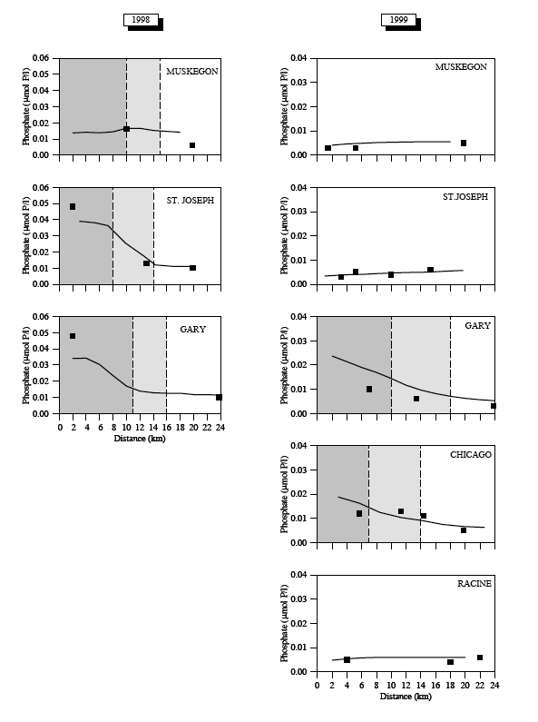
Model-Predicted and Observed Phosphate Comparison
Model-predicted phosphorus was in reasonable agreement with water samples collected on the three transects at Gary, St. Joseph, and Muskegon in 1998 and the five transects at Gary, St. Joseph, Muskegon, Racine and Chicago in 1999. Phosphorus concentration within the plume was significantly higher in 1998 than 1999. The model without nutrients released from suspended sediment failed to capture the high concentration of phosphorus within the plume, which suggests that benthic flux played a critical role in supplying nutrients in the sediment suspension area. When sediment resuspension occurred, detritus in the benthic layer was carried up into the water column where it was converted to inorganic nutrients through the remineralization process.
|
|
Comparison Between Model-Predicted and Satellite-derived Chal-a Concentrations
The model-predicted total phytoplankton abundance (a sum of small and large phytoplankton abundances) was compared with the remote sensing-derived chlorophyll-a concentration on the surface in 1998 and 1999. In 1998, the SeaWiFS chlorophyll image on 25 March showed a relatively high concentration zone of chlorophyll-a along the eastern and western coasts of the southern basin. The high chlorophyll-a concentration was advected offshore around Grand Haven and flowed following a cyclonic circulation to form a donut-like distribution pattern in the interior. This feature was captured by the model. In 1999, the satellite image on 20 March showed a relatively high concentration zone of chlorophyll-a around the southern coast. A tongue-like lower concentration area of chlorophyll-a was found east of Gary, which was consistent with a southward intrusion of the interior water found in the distribution of currents and temperature. These spatial distributions of the chlorophyll-a concentration were reproduced by the model, though model-predicted concentration of chlorophyll-a was relatively lower than satellite-derived chlorophyll-a observations.
|
|
| |
|
|