 |
Massachusetts Bay Modeling
|
Mass Bay is a typical inner bay connected to harbor, estuaries, numerous islands and sounds, narrow canal, wetland and tidal creeks along the coast and bounded by steep bottom topographic Stellwagan Bay in the western Gulf of Maine. In the last three decades, the water quality and productivity of Mass Bay have declined remarkably due to both natural environmental deterioration and land loading. It is challenge to develop an ecosystem model that is capable to resolve this complex dynamic system.
USGS at Woods Hole was the first team who developed the Mass Bay modeling system. Their system was built based on the structured grid alternative version of Princeton Ocean Model (POM) (called ECOM-si) with the state-of-the art water quality model. It is no argument that in the last 15 years, this model system has provided a great help in understanding the coupled physical and biological processes controlling the bay-scale 3-D circulation and water quality. Because of poor resolving of coastal geometry, this system is not capable to capture the inner shore processes interacted with estuaries, canal, and harbor.
Built on our experiences in POM/ECOM-si, we have developed an unstructured grid, finite-volume coastal ocean model for the Gulf of Maine region includidng Mass Bay (FVCOM-GOM/GB). By using triangular grid, the new model provides an accurate fitting of irregular coastal geometry of Mass Bay, Three generations of FVCOM-GOM/GB have been developed. Even first generation of FVCOM-GoM/GB has higher horizontal resolution than the existing Mass Bay ECOM-si based model and also provided a better resolving of Mass Bay coastline that was not captured by the existing structured grid model. The second generation of FVCOM-GoM/GB has a horizontal resolution of 500-m on Stellwagan Bank. Our modeling experiments show that the failure to resolve the bathymetry of Stellwagan Bank can lead to the unrealistic water exchange process between Mass Bay and Gulf of Maine. Funded by MIT Sea Grant Program, we have developed a third generation of FVCOM-GoM/GB with a nested subdomain Mass Bay model. In this version, the computational domain cover all details of Boston Harbor, estuaries, Cape Cod Canal, and innerbays along Cape Cod with a horizontal resolution ranging from 20 m to 500 m. This new model system provide an advanced model system in Mass Bay for the use of coastal management and water quality monitoring. A detailed description of the FVCOM-GoM/GB can be found in the website for the Gulf of Maine/Georges Bank. Here a brief description for the third generation of the subdomain Mass Bay model is given.
|
Mass Bay Subdomains in Three Generations of FVCOM-GOM/GB |
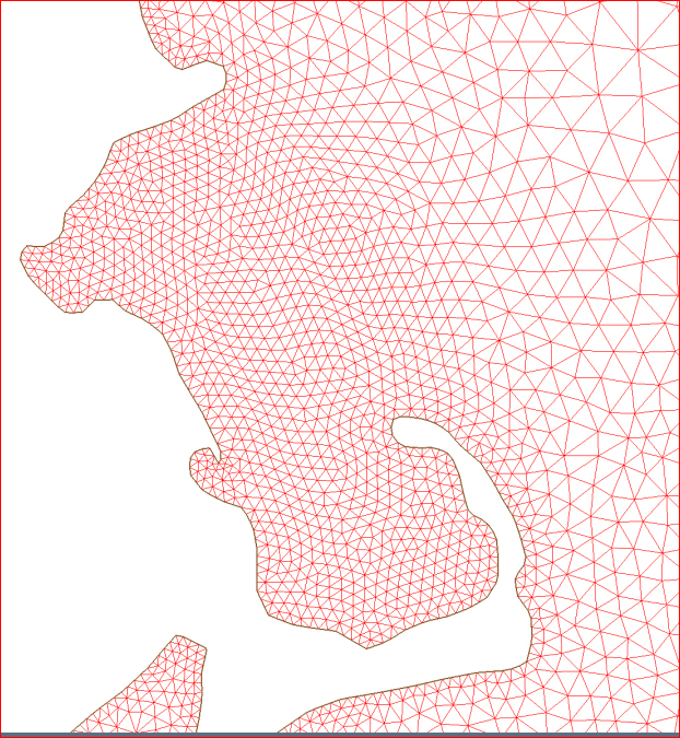
First generation
This was the first version of FVCOM-GoM/GB. In this model, the horizontal resolution in Mass Bay ranges from 0.8 to 3.0 km. This grid resolves the smooth shape of the coastline, but does not includes the detailed geometry of Boston Harbor, islands/sounds. It also does not resolve the steep bottom bathymetry of Stellwagan Bank at the outer edge of Mass Bay and Cape Cod Canal.
Click here or image to view the enlarged image of this subdomain cut from the first generartion of FVCOM-GoM/GB domain.
|
|
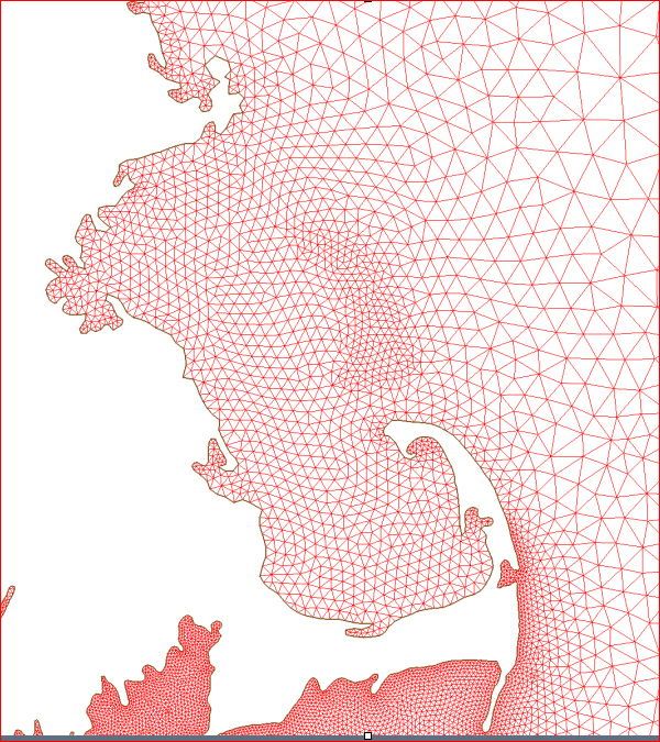
Second generation
The second generation of FVCOM-GoM/GB was modified by adding higher horizontal resolution in the coastal area. In Mass Bay subdomain, the horizontal resolution is up to 0.4 to 2.7 km and more grids were added over Stellwagan Bank to resolve the steep bottom bathymetry. This grid, however, still does not include the detailed geometry in Boston Harbor and resolve the Cape Cod Canal.
Click here or image on the right to view the enlarged image of this subdomain cut from the second generation of FVCOM-GoM/GB domain. |
|
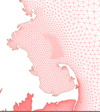
Third generation
The third generation of FVCOM-GoM/GB is the current version of our GoM model nested with high-resolution subdomain models. The right image shows the subdomain model covering the regions of Mass Bay, Nantucket Sound and Nantucket Shoals. This model is driven by the regional domain third generation of FVCOM-GoM/GB. The horizontal resolution of this model varies from 10 over the coastal area and around islands to 0.3-1.0 km near the nested area in the GoM and New England shelf.
Click here or images on the right to view some details of the unstructured grid in the Mass Bay.
|
|
Examples of Model Results |
It has been well-recognized that the Mass Bay circulation is characterized with energetic interaction between the bay and estuaries, inner sounds, and harbors. To simulate or predict the circulation in this bay, it is critically important to resolve complex inner shelf processes. For example, in 2005, the red tide was observed in the Mass Bay and then advected to Buzzard Bay through Cape Canal. It is impossible to resolve this process if a model fails to resolve the Canal. In addition, if a model fails to resolve steep bottom slope of Stellwagan Bank outer edge of Mass Bay, it would provide an unrealistic water exchange process between the bay and interior of the GoM.
Comparisons were made between three generations FVCOM-GoM/GB results in Mass Bay. A hindcast experiment was made for years 1995-2006. January and June of 1999 were selected here for examples. The rest model results were stored in the MEDM storage drives and these data have been used to drive the ecosystem model for the study of fish larval recruitment and prediction of right whales in the Great South Channel.
|
The First-Generation Model Results
Clicking here or image on the right will bring you into a page on which you can make a selection to view the animation of the 40-hour low-passed filtered subtidal currents over a yearly scale. The animations included in this page are from 1995 (an initial spin up year) to 2007, with the continous upload until present.
To make the animation viewable on a size-limited screen, the animation was made by re-sampled points. The SST data assimilation is included. The wind forcing and surface heat flux used in the hindcast simulation are output of the MM5 model with a horizontal resolution of 10 km.
Color is the surface water temperature and vectors are the near-surface currents. The model run was conducted with 31 sigma levels in the vertical.
|
|
The Second-Generation Model Results:
Clicking here or image on the right will bring you into a page on which you can make a selection to view the animation of the 40-hour low-passed filtered subtidal currents over a yearly scale. The only selected year was posted here.
As the same as the first generation model, we also included the SST data assimilation and used the wind forcing and surface heat flux from the output of the MM5 model with a horizontal resolution of 10 km. Without the data assimilation for currents, the model provides the accurate simulation of the currents observed along the coast.
The model output was archived with a hourly time interval. The archive database includes 1) 3-D velocity, 2) water temperature and salinity, 3) vertical eddy viscosity, 4) the sea elevation, etc. We also saved all the restart files for each year from 1995 to 2007 to allow us to re-generate the hindcast field for a selected year.
Color is the surface water temperature and vectors are the near-surface currents. The model run was conducted with 31 sigma levels in the vertical. |

|
The Third-Generation Model Results
The third-generated model is driven by the nested condition produced from the 3rd generation GoM/GB/NES model at open boundaries and the meteorological forcing produced by the WRF model with a horizontal resolution of 3 km. This high resolution model really improve the simulation in the near-coastal region and around islands and inside inlets, rivers, and bays.
Click here to view the animation of the M2 tidal currents and elevation over tidal cycles. We will upload the hourly field of the model hindcast currents, water temperatre and salinity on this page soon. To get an updated information, please contact Dr. Chen at SMAST.
|

|
|

