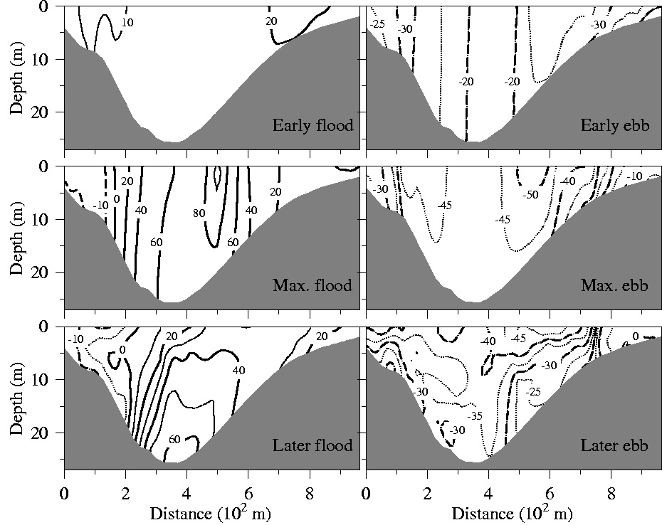
Model Validation, Code Parallelization, FVCOM Forum, FVCOM Registration, FVCOM User Login

Tidal Flushing and Eddy Formation

Tidal flushing and eddy shedding dominate the variation of tidal currents in NB/MHB. Tidal currents exhibit asymmetric properties in narrow channels, around islands and along headlands. An example can be seen in the MHB-NB channel. During the flood period, the water, which originates from the East Passage, flows around Hog Island, merges on the eastern side of the Island, and then flushes into MHB through the deep channel (Fig. 1a). Current separation on the lee side of flushing generates two eddies on lateral sides of the current jet near the maximum flood tide in MHB The eddy on the eastern side enlarges in size and its center migrates northeastward with time after the maximum flood, while the eddy on the western side is intensified as a result of an increase of the southward along-coastal tidal flow during the late flood phase. When tidal currents are reversed during the ebb period, two eddies occur on the lee side of the tidal flushing in NB. The eddy on the northern coast forms near the maximum ebb, while and the eddy on the southern coast appears 1-3 hours after the maximum ebb (Fig. 1b). 

Clike here or the image to view the full-size figures.

Clike here to view the animation of the tidal flushing process through the Narragansett Bay and Mt. Hope Bay channel.

Note here that the near-surface tidal currents shown in Fig. 1 (right) represent the case with the only tidal forcing. When the wind and river discharges are added, the current field might significantly varies. Also, the model grid did not resolve the concrete tower foundations of the Mt. Hope Bay Bridge. The local current distribution could differ from the ones shown here due to missing the tidal flushing around the foundation islands.

Tidal flushing results in the significant variability of the vertical and horizontal shear of tidal currents during the tidal cycle. In the homogeneous case with only tidal forcing, the along-isobath tidal current in the NB/MHB channel is almost uniform in the vertical during the early flood, with a maximum speed in the center of channel and decreasing toward the coast (Fig. 2: upper-left). This pattern remains unchanged until the maximum flood, during which a velocity 
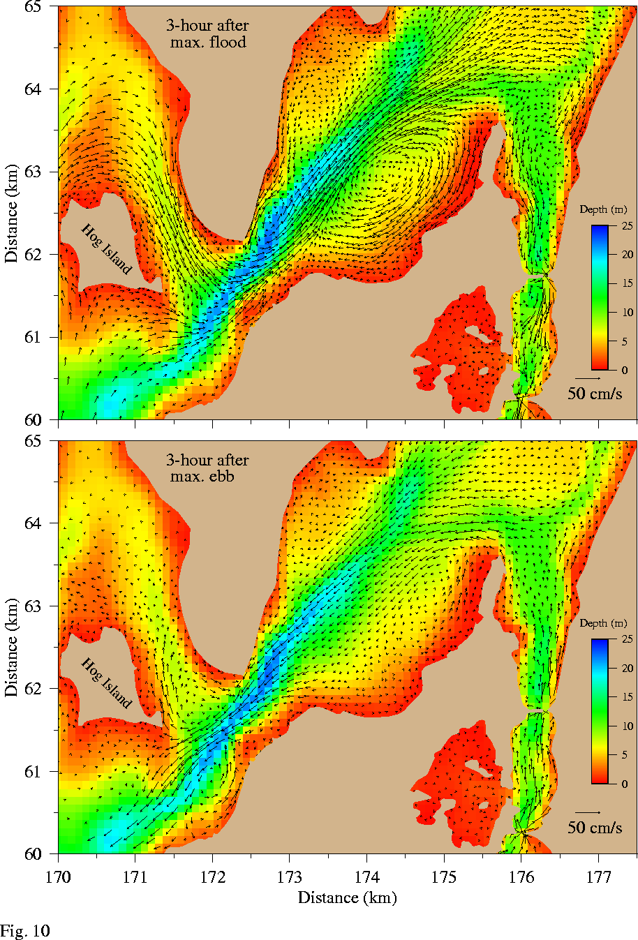
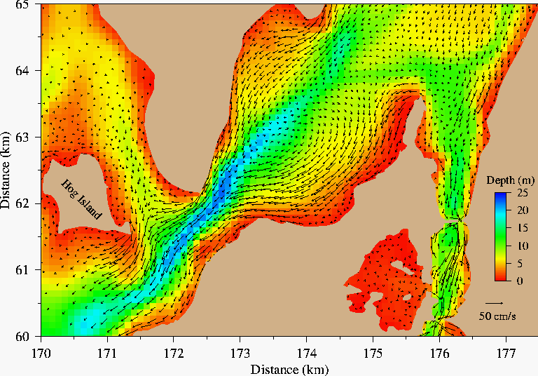
reversal occurs on the northern coast due to flow separation and the axis of the maximum tidal current shifts toward the southern side (Fig. 2: middle-left). Two hours after the maximum flood, however, a strong vertical shear occurs in the deep channel, with maximum current near the bottom, decreasing toward the surface (Fig. 2: lower-left). At this time, the water in the upper 10 m tends to move toward the southern coast, which is consistent with the formation of a large clockwise eddy in the southern coastal area.  The velocity returns to a uniform vertical profile again during the early phase of the ebb period, with a maximum outflow on the slope of the channel about 2 km away from the coast on both sides of the transect (Fig. 2: upper-right).  A significant vertical shear of tidal currents occurs at the maximum ebb, with the maximum velocity at the surface with depth

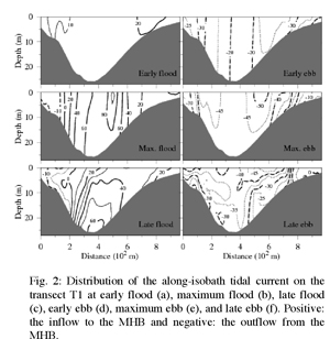
(Fig.2: mid-right). The vertical profile of tidal currents becomes much more complex in the later phase of the ebb period, during which the outflow is stronger on the southern coast than on the northern coast and is strongest at the surface (Fig. 2: lower-right).


Copyright © 2005
SMAST/ UMASSD
All rights reserved

Home           About Us           FVCOM            Research           Publications           Contact Us           FAQ