Model Validation, Code Parallelization, FVCOM Forum, FVCOM Registration, FVCOM User Login

Re-analysis of of Atmospheric and Ocean Conditions for the Lady of Grace Event and a Model System for Vessel Icing in the South Coast

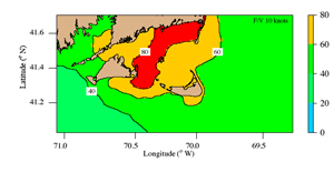
January 26, 2007 was a day with sad news that the New Bedford fishing vessel Ladyof Grace sank in Nantucket Sound.  The U.S. Coast Guard has said that the captain had reported severe icing problems shortly before sinking and thus the likely scenario for the demise of the ship is that the vessel stability was compromised due to the change in center of gravity stemming from heavy ice accretion.  The last communication between the Lady of Grace and the fishing vessel Lisa Ann II was at 10:00 PM EST, when the Lady of Grace was located about 12 miles south of Hyannis in Nantucket Sound.  The Coast Guard started searching at about 5:06 AM EST on January 27.  The sunken vessel was eventually found near Cross Rip Shoal, near an area where an oil sheen appeared on the surface on January 28, about two days after the Lady of Grace was reported missing.

In the wake of this tragic event, Dr. Brian Rothschild, co-director of the Massachusetts Fisheries Institute (MFI), University of Massachusetts-Dartmouth (UMASSD), suggested that Dr. Changsheng Chen, leader of the Marine Ecosystem Dynamics Model (MEDM) Laboratory, Department of Fisheries Oceanography, School of School of Marine Science and Technology (SMAST) use their integrated model system to reanalyze the weather and ocean conditions around the time the ship was reported missing to see if the conditions under which icing occur can be accurately forecast and thus able to provide information that could help prevent similar accidents in the future. Funded by the Fisheries Program of MFI, NSF, and NOAA, a team led by Chen (UMASSD) and Dr. Robert Beardsley (Woods Hole Oceanographic Institution) has developed an innovative integrated model system for the Gulf of Maine/Georges Bank region, with high horizontal resolution of order 0.3-1.0 km in coastal regions including Nantucket Sound and surrounding areas (see http://fvcom.smast.umassd.edu; Chen et al., 2003; Chen et al., 2006). Recently, with funding by MIT Sea Grant, they have increased the horizontal resolution of their ocean model (an unstructured-grid finite-volume coastal ocean model called FVCOM) to less than 100 m in Nantucket Sound.  Hindcasts made with this new model grid compare very well with WHOI moored water temperature and current measurements made by Senior Research Specialist Richard Limeburner and Beardsley during the last two years. This model system is now being transferred into an operational forecast system.  The ocean model is driven by surface forcing fields generated using a Gulf of Maine regional meso-scale meteorological model (GoM-MM5) (Chen et al, 2005); presently local 3-day weather forecasts with 10-km resolution hourly fields of air pressure and winds are posted on the SMAST website (http://www.smast.umassd.edu/).

Led by Rothschild, Chen, and Beardsley, a research team at the MEDM Lab, including Drs. Liuzhi Zhao and Geoff Cowles and graduate students Song Hu and Pengfei Xue, re-constructed the surface weather and sea conditions for the period January 25-29. A brief description of the air-sea conditions and potential for icing during this period is given below.

Figure 1 shows maps of the near-surface wind and air temperature over Nantucket Sound at 10:00 PM January 26, about the time of the last e-mail communication between the Lady of Grace and Lisa Ann II.  A strong northwesterly wind with speeds increasing to greater than 10 m/s occurred in Nantucket Sound and downwind, with air temperatures below -20 degree C near the Cape Cod coast warming slowly downwind as the air moved over the warmer sea.  

Figure 2 shows maps of the near-surface currents and surface water temperature at 10:00 PM January 26.  At this time, the tide was near the ebb-flood transition period, with relatively strong currents of greater than 0.5 m/s rushing into Nantucket Sound through the Nantucket Island/Cape Cod passage and flowing out through the Martha’s Vineyard/Nantucket Island passage and through Vineyard Sound. The surface currents inside the Sound were dominated by westward flow with speeds between 0.1-1.0 m/s.  Two hours later the currents were reversed.  Except near Nantucket Island, surface water temperatures in Nantucket Sound were generally between 2-3 degree C, with warmer temperatures downwind from Nantucket.    

Figure 3 shows the significant surface wave height Hs distribution at 9:00 PM January 26 predicted using the SWAN (Simulating Waves Nearshore) model by Dr. Vijay Panchang and his research group at Texas A&M University (see http://www.gomoos.org/waveforecasts/ ). Defined as the average height of the one-third highest waves, Hs increased towards the southeast, from less than 0.5 m near Cape Cod to between 1-2 m north of Nantucket and exceeding 2 m further downwind.

Figure 4 shows a map of vessel-icing during the night of January 26 predict that the Lady of Grace was steaming into waves in an area with mid-moderate up to heavy icing rates. Star was the location where the boat was found.

PR: Predictor Rate: four classes: 1) light (PR <20.6 m degree C/s); 2) moderate (20.6 <PR< 45.2 m degree C/s); 3) heavy (PR> 45.2 m degree C/s) and 4) extreme (PR> 70.0 m degree C/s).

PR rate shown in the figure on the right was estimated for the condition that the boat did not move.

Figure 5 shows a map of vessel-icing during the night of January 26 predict that the Lady of Grace was steaming into waves in an area with mid-moderate up to heavy icing rates. PR shown in the figure on the right was estimated for the condition that the boat moved against the wind at a speed of 10 knots
Figure 6 shows the results of a model simulation of 100 surface drifters randomly deployed in a south-north zone across Nantucket Sound at 10:00 PM January 26 and tracked for 18 hours. The trajectories of these “model” surface drifters clearly show a tendency to move eastward. This suggests that if the Lady of Grace lost power, it should drift to the east. Since the vessel was eventually found in Cross Rip Shoal, it suggested that the Lady of Grace sank quickly when icing occurred after it moved into the high icing rate and surface wave zone in Nantucket Sound.
This re-analysis of the marine weather and ocean conditions in Nantucket Sound and surrounding waters during January 25-29, 2007, suggests that the coupled atmosphere/ocean model system developed at UMASSD is available for predicting surface icing conditions for fishing vessel application. This system should be set up to serve the local fishing industry. This model system can have a wide variety of uses, including search and rescue application, storm surge and inundation, and marine resource management.


Copyright © 2005
SMAST/ UMASSD
All rights reserved

Home           About Us           FVCOM            Research           Publications           Contact Us           FAQ