|
Tidal Simulation
Long-term measurements for tidal elevations were made at 7 sites labeled A-C in the Little Ogeechee River (the northern main channel of the estuary) and D-G in the Ogeechee River (the southern main channel of the estuary) by Dr. Blanton and his co-workers at the Skidaway Institution of Oceanography,Georgia.Harmonic analyses were used to construct amplitudes and phases of five major tidal constituents of water level at these 7 sites. Note that because of unknown instrument problems, the data records at site E showed a bias shift in a late period. |
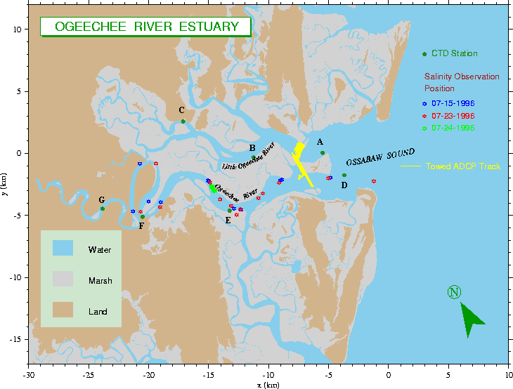 |
Fig.1 Ogeechee River Estuary (the observation sites of tide and salinity are shown in different legends)
Click here or image to view larger image |
|
Although those parts of the data were removed before harmonic analysis was conducted, it is unclear whether the data before jump occurred are reliable. Therefore, the model-data comparison at that point must be interpreted with caution. |

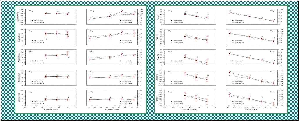
Fig.2 Comparison between model-predicted (dashed line) and observed (solid line) amplitudes and phases of M2, S2, N2, K1 and O1 tidal constituents. The red bars indicate the uncertainty range of tidal measurement. Click here or image to view larger image |
The model was first run for tidal simulation over 45 days and then model-output water levels were processed using the harmonic analysis program. The model-predicted amplitudes and phases of five major tidal constituents were directly compared with observations at sites A-C in the Little Ogeechee River and sites D-G in the Ogeechee River
The comparison results show that the model has provided a reasonably accurate simulation of the amplitudes and phases of semi-diurnal (M2, N2, and S2) and diurnal (K1 and O1) in both northern and southern main channels of the Ogeechee River Estuary except at site E. In general, the difference between model-predicted and observed tidal constituents was less than 2-3 cm in amplitude and less than 5o in phase. The model-data difference for S2 tidal constituent was a little bit larger than 3 cm, but it is still within uncertainty level of field measurement. Similarly, there are some significant phase differences between model-predicted and observed values, but most of them were within uncertainty level of the measurement. Model-predicted amplitude of M2 tidal constituent at site E was significantly lower than the observed value. Because we are not sure whether the data received at site E was reliable due to the sudden jump of the records, it is difficult to judge whether it is a model problem or instrument problem. Since the model has shown a good agreement with observations at other 6 stations and the data records at site E are questionable, it makes us believe that our model works well for tidal simulation in the Ogeechee River Estuary |
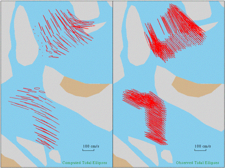
There were no many tidal current measurements made in the Ogeechee River Estuary. Recently, Dr. Li at Skidaway Institute of Oceanography conducted a tow-ADCP survey near the inner end of the Ossabaw Sound. Because of difficulties in removing noises when the ship was close to the land or marsh area, ADCP data recorded near the coast seemed to overestimate the amplitude of tidal currents. Excluding the data close to the coast, the ADCP-derived M2 tidal ellipses in the center of the channel seemed to be consistent with model-predicted values. This suggests that our model captured the nature of tidal motion in the Ogeechee River.
|
 |
Fig.3 Comparison between tow-ADCP-derived and model-predicted M2 tidal current ellipses. Note that the ADCP-derived ellipses close to the land or salt marsh were not reliable due to significant uncertainty of measurement.
Click here or image to view larger image |
|
| |
|
|
|