|
We have set up the MM5 (the fifth-generation mesoscale meteorological model) for the SAB. MM5 is a regional nonhydrostatic, terrain-following, sigma-coordinate weather model developed jointly by the National Center for Atmospheric Research (NCAR) and Pennsylvania State University (PSU) (Dudhia et al. 2003). This model was developed originally by Anthes and his colleagues at PSU in the early 1970’s (Anthes and Warner 1978) and modified by NCAR/PSU modelers to include a multiple-nesting capability, nonhydrostatic dynamics, and four-dimensional data assimilation capability (Grell et al. 1995).
The SAB MM5 includes the data assimilation of the surface wind velocity with all available meteorological buoys in the computational domain and also an improved heat flux alogrithm introduced into MM5 by Chen et al. (2004). The improved MM5 provides the hourly wind and heat flux fields with a horizozntal resolution of 9 km over the entire SAB region and also 3 km-resolution wind and heat flux fields over Georgia shelf. Like the Gulf of Maine MM5, the SAB MM5 is on the forecast and hincast modes. The examples of the hincast model run is posted at this website.
We are working on replacing the MM5 by the Weather Research Model (WRF), a new generation meso-scale meteorological model with advanced numerical schemes and better boundary parameterization. We expcct that WRF could provide us with a 1-km resolution wind and heat flux fields that can be used for shelf and estuarine studies.
|
The South Atlantic Bight MM5 is configured with regional, local and estuarine computational domains with horizontal resolutions of 27, 9, and 3 km, respectively (see figure below). The regional domain consists of 65x65 grid points (area: 1728x1728 square kilometers), the local domain includes 133x133 grid points (1188x1188 square kilometers), and the estuarine domain contains 85x97 grid points (252x288 square kilometers). A pressure-defined sigma-coordinate transformation is used in the vertical. This is a terrain-following system in which sigma-levels follow the terrain near the bottom, gradually flattening as the pressure decreases and remain flat in the upper atmosphere. A total of 31 sigma-levels were specified for all regional, local and estuarine domains and the thickness of each layer depends on the reference-state pressure, finer in the surface boundary layer than in the upper atmosphere. The thickness of the surface layer is 20 m.
The meteorological data with hourly time intervals are nudged into the model run to merge the computed field to the observational field. This nudging assimilation approach ensure the relative reality and accuracy of the model-predicted meteorological field and make it useful for the coastal and estuarine application.
|
MM5 Domain
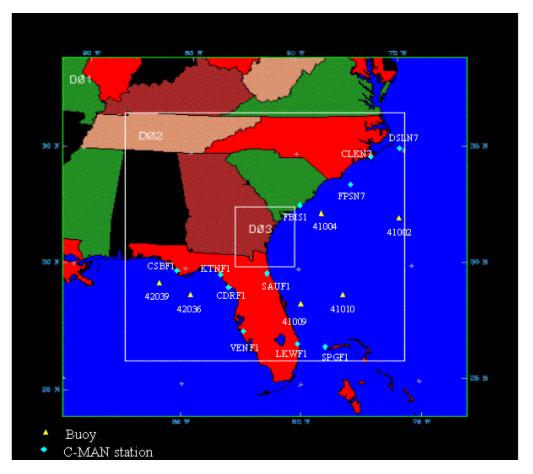
D01, D02 and D03 represent the regional, local and estuarine computational domains, respectively. Blue filled dots are locations of the C-MAN stations and yellow filled triangles are the location of the NOAA meteorological buoys. Click here or figure to see the full-size domain
|
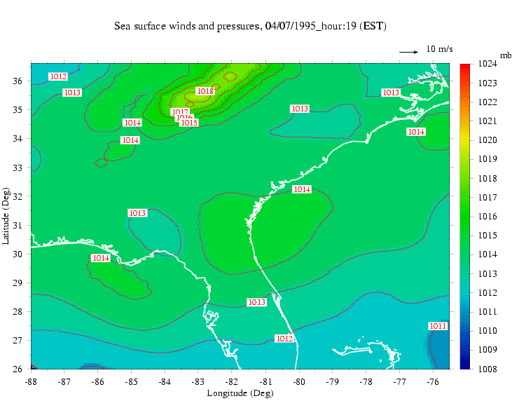
Example of MM5 Predicted Winds
The animation of the surface wind vectors and air pressure for the hincast run of MM5 over the SAB. The SAB MM5 domain is much larger than the one shown in this example.
The key point here is that wind and heat flux fields vary significantly with time and space. No matter how many efforts we made on making a better ocean model, if we could not be able to get the high-resolution wind and heat flux fields correct, we would not able to simulate the temporal and spatial variability of the current, salinity and temperature in the SAB.
The SAB MM5 is now merged to WRF. Click here or figure to view the full-size animation.
|
|
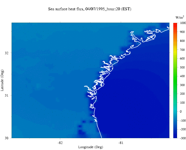
Example of MM5-predicted Heat Flux
The animation of the net surface heat flux predicted by the SAB MM5. The heat flux in MM5 is calculated using the modified PBL model introduced into MM5 by Chen et al. (2004). This modified version considers the realistic ocean condition and also validated by a direct comparison with the long-term heat flux measurement.
It should be pointed out here that the modified MM5 still fails to predict the correct short-wave radiation. The calibration of the short-wave can be made by using the satellite-derived cloud data. For details, contact Dr. Changsheng Chen.
Click here or figure to view the full-size animation.
|
|
|