The hydrodynamic model used in this system is the updated version of FVCOM. This model consists of 7 primitive oceanic governing equations (three for momentum, one for incompressible continuity, two for temperature and salinity, and one for density). Currents, temperature and salinity in the model are computed in the integral form of the equations, which provides a better representation of the conservative laws for mass, momentum and heat. This is a prognostic model with the free surface and mathematically is closed using either modified Mellor and Yamada level-2.5 (MY-2.5) or k-e (be sure to add the epstin sign here) turbulent closure schemes for vertical mixing (Mellor and Yamada, 1982; Galperin et al., 1988, Burchard et al. 1999). The model uses the sigma-transformation in the vertical to convert irregular bottom topography into a rectangular computational domain for simple numerical approach. Time variable river/dam and onshore intake/outflow discharges are included in the model for the study of the estuarine and coastal fronts driven by freshwater discharges and tidal/wind mixing.
|
A mass conservative wet/dry point treatment technique has been incorporated into FVCOM for simulating of the flooding/drying process over the estuarine-tidal creek-inter-tidal salt marsh complex (Chen et al., 2004). A critical layer hc is introduced into the model to avoid signality problem when the water depth reaches zero at the wet-dry boundary. The total water depth is refined as D = h(x,y)+z(x,y,t)+hc, where h(x,y) and z(x,y,t) are the mean water depth at the rest and water elevation (Zhen et al., 2003). If D is larger than hc, the point is treated as a wet point and its velocity and elevation are computed. Otherwise it remains a dry point where water velocity and elevation are equal to zero. In terms of physics, the critical layer is just like a large, viscous, motionless layer near the bottom. Technically, this layer should be very thin in order to satisfy the motionless condition. This approach is very much like adding a porous medium with a thickness of hc into the model (Ip et al. 1998). The advantages of this approach are: (1) simplicity; (2) allows a conservative mass without sacrificing the s-coordinate in making a perfect match of the irregular bottom topography; and (3) allows arbitrary discretion resolutions in the vertical. The thickness of the critical layer used in our Satilla River model is 5 cm. This value is determined based on sensitivity studies of velocity and tidal elevation to hc.
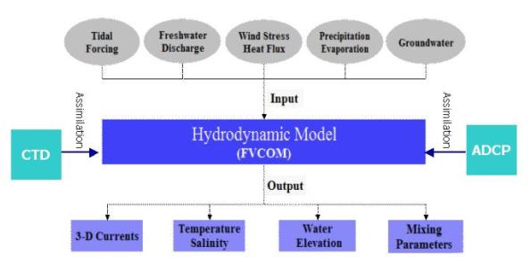
The major forcings for FVCOM are 1) the oscillation function with specified tidal elevation and phases of M2, S2, and N2 (semi-diurnal) plus K1 and O1 (diurnal) tidal constituents at open boundary over the shelf, 2) the surface wind stress and heat flux, 3) the precipation via evaporation; 4) the daily freshwater discharge at the upstream monitoring station at Atkinson, GA; and 5) the groundwater flux at the bottom. The tidal forcing at the open boundary is provided from the output of the South Atlantic Bight tidal model developed by Chen et al. (1999). The wiind stress, heat flux and precipation via evaporation are output directly from the meso-scale meteorological model (MM5) with hourly time intervals and 3-km horizontal resolution. Freshwater discharge is downloarded directly from the USGS website (USGS 02228000)
In order to make FVCOM-WQ into operation for the purpose of the coastal management, a four-dimensional nudging data assimilation (FDNDA) has been incorporated into the model system to ensure the accuracy of forecasting for both physical and water quality elements. Nudging is a continuous (every model time step) dynamical assimilation in which forcing functions are added to the governing model equations to gradually “nudge” the model states toward the observations. This method is the simpliest assimilation method with more flexibility to be used for any type of data sets which are either measured over a regional scale or at fixed locations.
The updated code of FVCOM is written in FORTRAN 95/2K with parallelization (Cowles et al., 2004). The implementation of the parallelization is a SPMD (Single Program Multiple Data) approach and uses a message-passing model to perform the necessary inter-processor communication and synchronization. The physical domain is decomposed into sub-domains using the METIS graph partitioning libraries. Each sub-domain is assigned to a processor for integration of the model equations. To compute the flux at the sub-domain (inter-processor) boundaries, flow data must be exchanged among processors. The exchange subroutines utilize non-blocking sends and receive from the MPI (Message Passing Interface) 2.0 library. The efficiency of the application can be measured in terms of its speedup and/or scalability on a multiprocessor computer. These metrics are dependent on a good load balance from the domain decomposition and minimization of the communication overhead. The parallel code the satilla River FVCOM is currently run on an 8-node (16 CPU) IBM cluster at the computer center of the University of Georgia.
The updated verision of FVCOM includes many new functions, such as 1) an interface library for the General Ocean Turbulence Model (GOTM) (An open-source community model developed by Burchard et al (1999): http://www.gotm.net); 2) multiple choices of radiation open boundry conditions, 3) ghost treatment for solid boundary conditions; 4) momentum and tracer balance analysis tool; 5) online and offline Lagrangian tracking program, etc. GOTM implements a number of turbulence modules with a range from a simple Richardson parameterization to complex Reynolds-stress turbulence closure models (Umlaf et al, GOTM users’ manual version 3.0). These turbulence modules allow us or managers to choose different vertical turbulent mixing parameterizations depending on the nature of the turbulent motions.
FVCOM Domain Configuration
FVCOM computational domain is constructed using the non-overlapped unstructured triangular meshes with the best fitting of iregular geometries of the coast, islands, tidal creeks, and barriers. The horizontal resolution varies from 50 m inside the river and tidal creeks to about 10 km near the open boundary over the inner shelf.
Click here or figure for the detailed information of the domain configuration for the Satilla River FVCOM.
|
|
|