Model Validation, Code Parallelization, FVCOM Forum, FVCOM Registration, FVCOM User Login

THE CHANGJIANG RIVER

The Changjiang River is the largest river in the East China Sea, which directly controls the regional circulation and stratification. "The River has complex coastal geometry and abruptly-varying bathymetry. It is divided into southern and northern branches by Chongming Island. Two smaller islands are located in the mouth of the southern branch, which divides this branch into two channels. At the mouth of the river, the bottom topography features four “deep” passages connected to the southern branch. There are also two relatively deep passages linked to the northern branch (quoted from Chen et al. 2005)."

Click here or image to view a big size figure.

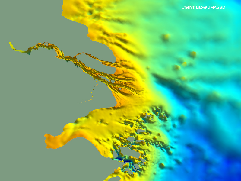
"In the summer flood season, the Changjiang freshwater water splits into two streams at the northern tip of Chongming Island which flow out onto the inner shelf of the ECS through southern and northern branches. In the winter dry season, the Changjiang freshwater water flows into the ECS primarily through the southern branch and a salt-water return flow is frequently observed in the northern branch (quoted from Chen et al. 2005)". This is a complex esturine system characterized by fronts and eddies.

"Harmful algal blooms (‘‘red tides’’) occur primarily in a confined region on the inner shelf off the Changjiang River in the East China Sea during May–August. The areal extent of these blooms has increased dramatically in the last decade, and was associated with 1) the rapid increase in nutrient supply via the Changjiang River, 2) the water transport from the Taiwan Warm Current and 3) enrichment of organic matters in the sediment (see Chen et al. 2003).

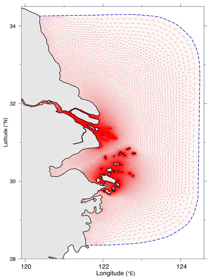
As Zhijiang Scholar, Dr. Chen has been collaborating with Dr. Pingxing Ding, Director of the State Key Laboratory for Coastal and Estuarine Research, East China Normal University, on developing an ecosystem model for the Changjiang River Estuary. Dr. Ding is leading the interdsciplinary field measurement in the Changjiang and over the inner shelf of ECS, and the MEDM Laboratory at UMASSD helped them to set up FVCOM system for this region. An integrated ecosystem model has already configured for this river, which includes: a) FVCOM-hydrodynamics, b) 3-D sediment model, c) generalized biological models, etc. We are working on converting SWAN into the unstructured grid finite-volume version. Once this model is developed, a fully integrated Changjiang River model system with advanced data assimilation package will be placed into operation.

In the past, we have focused our modeling experiments on process-oriented studies of this complex system. Some examples are posted here to share with the public. To learn the details, please contact Dr. Chen at c1chen@umassd.edu.

The Changjiang River FVCOM

The Changjiang River FVCOM was configured by P. Xue, H. Lin and C. Chen at the MEDM Laboratory/UMASSD. This model is a subdomain of the FVCOM-ECS/JES, with a nesting approach through the same nodes at the boundary shown as the dashed line. Horizontal resolution varies from 100 m inside the river and around islands to 1-2 km over the inner shelf of the ECS. A 3-D wet/dry treatment method in FVCOM is turn on in this domain, which allows us to simulate the flushing process onto the wetland.

This high-resolution model was well tested by driving it using freshwater discharge and winds. The code and configuration has been delivered to our collaborator Dr. Ding's group in Shanghai. A paper about our modeling results is being written by P. Xue. C. Chen, P. Ding and R. C. Beardsley. For the updated information, please contact Chen at c1chen@umassd.edu or cchen@whoi.edu.

Click here or image to view a big size figure.

Tidal Animation

Tidal simulation was conducted with inclusion of 5 major tidal constituents. An example for the model run driven by the only M2 tidal forcing is shown here. This animation was made by the Open-DX with selected velocity points for a given search radius, so many features were filtered in this movie. Also, to give a clear view of two branches, the branches were enlarged in the x-coordinate of the figure. We will update this animation using our ViSiT visualization tool soon.

Click here or image to watch a large size animation.

River Plume in the Wet Season

An experiment was made to test if FVCOM is capable of resolving the fine spatial and temporal structures of the Changjiang Plume under a wet season condition. The model was driven by the tidal forcing at open boundary and a typical freshwater flux at the upstream end. The initial salinity was specified as a uniform value everywhere. No winds are included in this case. We also made an experiment with variou winds.

Be sure that this is just an example for the idealized condition. For the information about the real simulation, please contact us at c1chen@umassd.edu or visit our East China Sea web page on this site.

Click here or the image on the right to view the animation.


River Plume in the Dry Season

This is an example showing the salt water intrusion into the Changjiang River during the dry season. Driven by the only tidal forcing under a freshwater discharge rate, the model does show an upstreamward intrusion of the salt water from the northern channel.

The physical mechanism causing this evidence has been studied theoretically and numerically and the results are being written into a paper. For details, please contact us.

The northerly wind tends to enhance the intrusion, which can be viewed clearly in the animation on the right.

Click here or the image to view the animation. The model was run with the tidal and freshwater discharge first and the northerly wind was then added later.


Is the human-made dams helpful to improve the navigation channel and sediment transport?

A few years ago, two dams were built on the sides of the navigation channel to "enhance the sediment transport and improve the navigation condition due to the sediment accumulation." However, this is an ocean where the tidal current rotates with time over tidal cycle, such an action would not be able to reach the goal people expect.

Click here or the image on the right to view a full size of the animation.


Copyright © 2005
SMAST/ UMASSD
All rights reserved

Home           About Us           FVCOM            Research           Publications           Contact Us           FAQ