Model Validation, Code Parallelization, FVCOM Forum, FVCOM Registration, FVCOM User Login


SAB ECOM-si

ECOM-si was first applied to study the cross-frontal water exchange in the inner shelf of the SAB by Dr. Changsheng Chen in 1996. At that time, ECOM-si was the most advanced coastal ocean model that was widely used by scientists in the coastal community. The objective of that modeling work was to study numerically the physical processes associated with the low-salinity front over the inner shelf of the SAB, with particular interests in (1) physical mechanisms responsible for the formation, evolution, and perturbation of the front and (2) cross-frontal water exchanges.

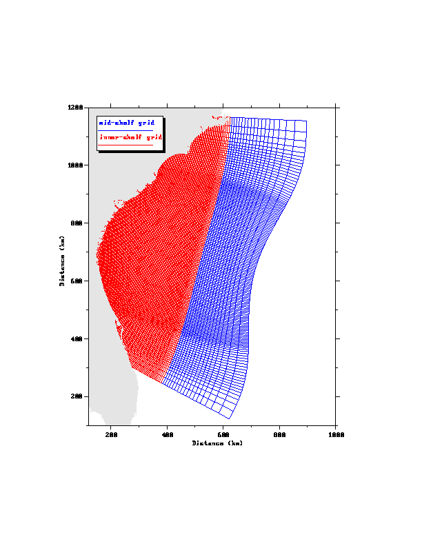
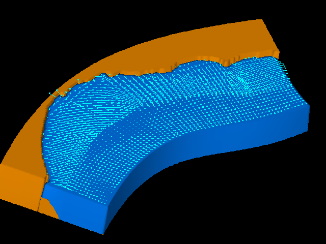
We did experienced difficulties in generating the orthogonal grid to provide a moderate fitting of the coastline and making the high resolution along the coastal region. We have changed several times of our model grids. One shown here is the high resolution one we used in the cross-frontal water exchange study. The horizontal resolution in this grid was about 1 km in the inner shelf and 10 km near the open boundary.

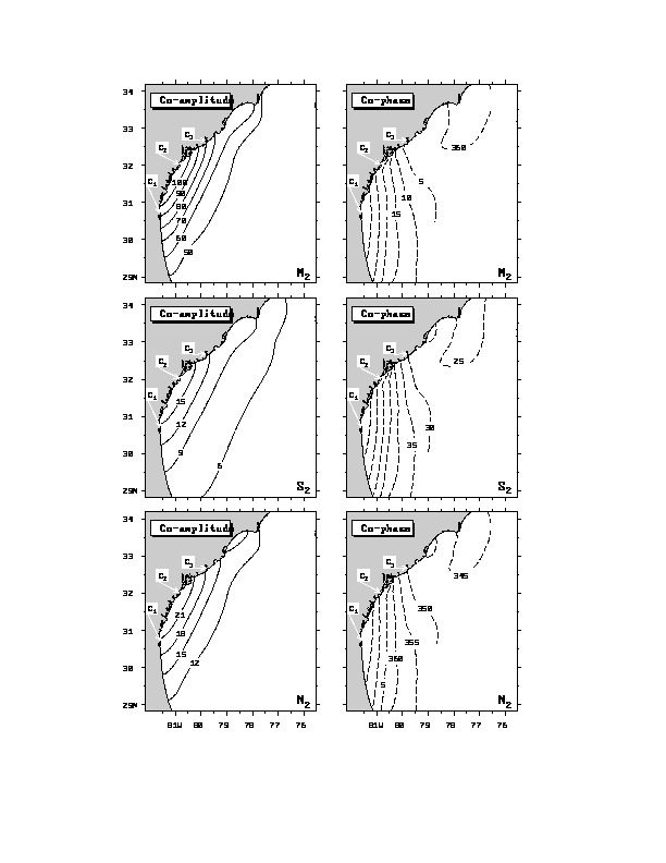
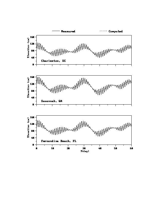
The ECOM-si was forced by semidiurnal tides (M2, S2, and N2), multiple river discharges (10 rivers), and winds. This model has provided a reasonable simulation for the M2 tides and also fortnightly/monthly variation of semidiurnal tides along the coast. The tidal model was only validated using the 3 tidal gage data and a few previous current records in the inner shelf. The good tidal simulation was approached by tuning the tidal forcing at the open boundary.

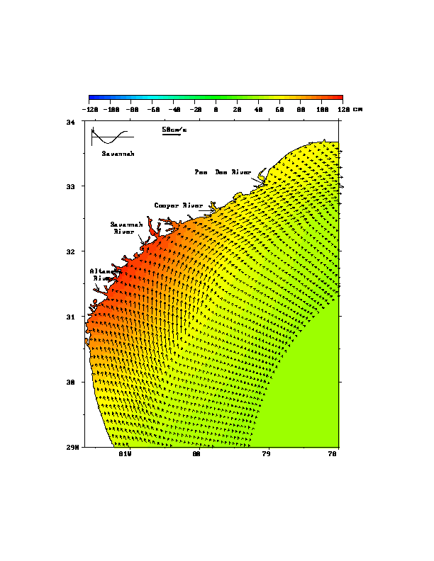
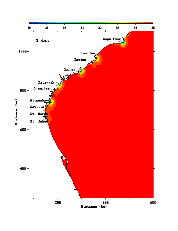
We examined the physical mechanism responsible for the offshore cross-frontal detachment of low-salinity water in the inner shelf.  The offshore detachment of the low-salinity water was well-recognized SAB shelf salinity feature, which was often mis-interpreted to the groundwater by some non-physical oceanographers.  Our numerical experiments clearly show that the low-salinity water found in the mid-shelf of SAB comes from the inner shelf due to the detachment of the low-salinity water from the inner shelf low-salinity front. Physical mechanisms controlling this detachment is very complex, which is related to (1) wind speed, (2) amount of river discharges, and (3) tides.

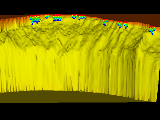
For the case with small river discharges, isolated low-salinity lenses formed episodically in two step. At first, a geometrically controlling wave-like frontal shape developed at the outer dege of the frontal zone as a result of the interaction between tides, multiple river discharges, and upwelling-favorable wind. Then, isolated low-salinity lenses fromed at the crest when water on the shoreward side of the crest is displaced by relatively high salinity water advected from the upstream trough of the crest and diffused upward from the deeper region. In this case, wind-induced upwelling is noticeable to compensate for the water loss due to the near-surface offshore Ekman transport, but it doesn't play critical role in the formation of the lenses.

For the case with large river discharges, stronger wind was required to form the isolated lenses and also tidal mixing acted like a drag forcing to delay the occurrence of isolated lenses. In this case, isolated low-salinity lenses formed due to upwelling and vertical diffusions.

Curvilinear structured grids of the SAB ECOM-si. The high-resolution area were marked with red color grids. Horizontal resolution was about 1 km around the coast and 10 km off the shelf. The grid was generated with a moderate fitting of the coastline, but we never could do it using the structured grid. We have modified ECOM-si to introduce the non-orthogonal coordinate, which removes the restriction of 90 degree in the orthogonal curvilinear coordinates. It did improve the coastal fitting, but still is far away to resolve the complex irregular coastlines around the coast and in estuaries. Click here or figure to view a full size figure.


Co-tidal charts of semidiurnal tides (M2, S2, and N2). No diurnal tidal constituents were taken into the tidal simulation. Be aware that the tidal validation was made only by 3 tidal gage data around the coast. The best agreement of tidal elevation at these 3 stations was a result after the open boundary forcing was adjusted. Click here or figure to view a full size figure.


Fouthfortnightly/monthly variation of semidiurnal tides along the coast. The model does not include the diurnal constituents. The diurnal components were not taken into account based on their minor contributions to the total tidal elevations. Click here or figure to view a fill size figure.


2-D view of the tidal animation. This animation was made based on the M2 tidal output with the free graphics software "GRI". The current vectors were selected every few grid points to produce a viewable animation. Click here or figure to view the animation.


3-D view of the tidal animation. This animation was made using the commerical software. The animation software was good one, but it was difficult to learn how to use it. A Fortran program is needed to prepare the data for animation. We stoped using this software after the Open DX was available. Click here or figure to view the animation.


A 2-D view of the formation of the low-salinity front due to freshwater discharges from rivers. In this idealized experiments, the discharge rate of each river is specified using its 20-year mean value. The background salinity is specified as a constant (35 ppt). Click here or figure to view the animation.


Animation of the formation of the low-salinity front. An idealized case model resuls for the river discharge case. The only two forcings were considered in this case: 1) tides and 2) river discharge. Click here or figure to view the animation.


The animation of the salinity variation on the cross-shelf section during the upwelling-favorable wind event under the background condition with tides and river discharges. Click here or figure to view


The animation of the near-surface salinity under the upwelling-favorable wind condition. This animation clearly shows that the low-salinity water can cross the inner shelf front and enter the mid-shelf. The suggestion about the groundwater output over the mid-shelf is hard to believe it is true. Click here or figure to view the animation.


A 3-D view of the fluid particle trajectories over the inner shelf of SAB before and during the upwelling-favorable wind condition. All the particles are released along the coast before the wind forcing is added. It is interesting that the cross-shelf movement of particles really follow the local bathymetry. Click here or figure to view the animation.


Copyright © 2005
SMAST/ UMASSD
All rights reserved

Home           About Us           FVCOM            Research           Publications           Contact Us           FAQ